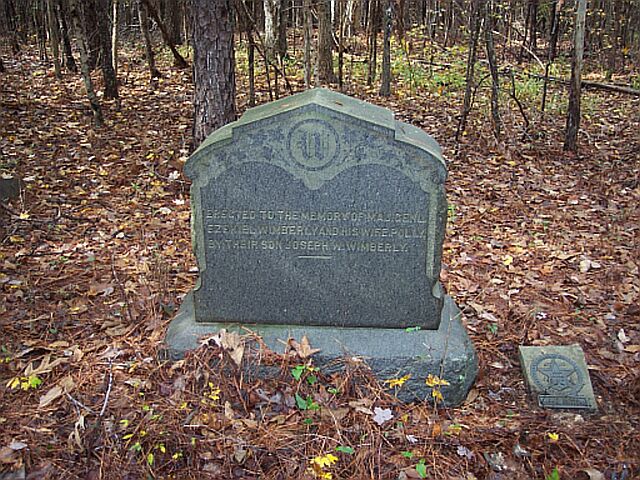
Ezekial Wimberley Cemetery photo courtesty of Bruce Hutchins |
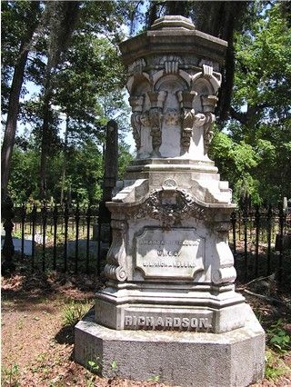
Old Richland Baptist Church Cemetery photo courtesty of Joy McCook |
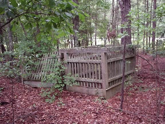
West - Martin Cemetery photo courtesty of Hugh T. Harrington |
|
Ezekial Wimberley Cemetery photo courtesty of Bruce Hutchins |
Old Richland Baptist Church Cemetery photo courtesty of Joy McCook |
West - Martin Cemetery photo courtesty of Hugh T. Harrington |
Military
Burials in Twiggs County
View
and/or Download a DOT County Map. Lots of cemeteries shown.
A
| Aires-Meadows Cemetery | Near intersection of W, Clyde Moore &
Cary Rd. Rd., Southwest of Danville
GPS 32° 32' 59"N, 83° 19' 56"W Map |
| Antioch Cemetery Listings (link) | Hwy. 18, next to Antioch Baptist Ch, GPS 32° 47' 43"N, 83° 28' 00"W Map |
| Andrews Cemetery | 6019 Marion Road. Map |
| Ard Family Listings (link) | - |
| Arrington Listings (link) | Old Marion Rd, near White Springs Baptist Church, African American |
| Asbell-Lamb-Sanders Listings (link) | Patricia Rd, off Hwy 96 |
| Baker, Charles Cemetery | Baker Rd, 14.7 miles from Jeffersonville, off Griswoldville Rd. NW near Jones Co. line, GPS 32° 52' 18"N, 83° 26' 57"W |
| Barnes-Hinson Listings (link) | Caleb Hinson, Rev. Soldier buried here |
| Beckham Grave | South of Bullard
GPS 32° 37' 33"N, 83° 29' 17"W |
| Beckham Cemetery aka Beckham-Fort Listings
(link)
(Brooks markers) |
Marion, southwest of Jeffersonville
GPS 32° 37' 13"N, 83° 29' 05"W |
| Beech Spring Methodist Cemetery Listings (link) | Bullard Road. GPS 32° 38' 18"N, 83° 28' 45"W Map |
| Bethlehem Church Cemetery | Southwest of Jeffersonville
GPS 32° 38' 09"N, 83° 30' 54"W |
| Birdsong Cemetery Listings (link) | across street from New Haven Baptist Church Cemetery |
| Bond Cemetery Listings (link) | 11.8 miles from Jeffersonville on old Marion
Rd. near Bibb Co.line
GPS 32° 44' 18"N, 83° 31' 25"W |
| Samuel Bragg Family Listings (link) | Maddux/Old Macon Rd. off Hwy 57 E. GPS 32° 51' 48"N, 83° 23' 21"W |
| Brown Hill Church | Black, near Danville. Some burials 1919: Infant son of Mary Anderson & Jack Clay Hazel May Clay, child of Clara Atmore & Bee Clay; Frances Hall. 1920: Albert Lee Allen; Lizzie Gainey. 1921: John Ruskin Clay. 1922: Infant son of Alberta Anderson; Tom Anderson; Lucy Coombs. 1923: Hattie Lee Gainey, daughter of Hubert & Julian Anderson Gainey. 1924: Walter Anderson, son of Alberta Anderson. |
| Bryan Cemetery Listings (link) | Western Twiggs |
| Burkett Cemetery Listings (link) | 11.7 miles Northwest of Jeffersonville,
Hwy. 80.
GPS 32° 46' 38"N, 83° 29' 53"W |
| Burns Cemetery | 10.2 miles from Jeffersonville, on King
Road, off Lizzie Harold Church Rd.
GPS 32° 32' 30"N, 83° 23' 08"W |
| Cannon Listings (link) | off Hammock Rd. |
| Chance Hill Church Cemetery | GPS32° 42' 18"N, 83° 32' 32"W |
| Concord Church Cem. Listings (link) | SE of Jeffersonville, near Wilkinson Co. line GPS 32° 39' 25"N, 83° 16' 45"W |
| Cool Spring Primitive Baptist Church Cem. Listings (link) | Cool Springs Rd. GPS 32° 34' 20"N, 83° 17' 35"W |
| Coombs Cemetery Listings (link) | " land district 24, Aerial View #37, in Land block #70. The cemetery is located near the intersection of Highway 96 and Highway 358. At the first dirt road west of the intersection, called Dirstrict Road, turn north and look for Richland Creek. When you cross Richland Creek look for the the first logging road on the left(West). There is a steel locked gate. The cemetery is about one quarter of a mile up the logging road at the crest of a hill." Billey Miller |
| Corn Cob Cemetery | - |
| Crocker Cemetery Listings (link) | The cemetery is on the west
side of Marion Ripley Road. The GPS coordinates for the cemetery are:
N 32.671794 and E -83.440556. Submitted by Jay French |
| Crosby -Pettis Cemetery Listings (link) | - |
| Danville City #1 Listings | - |
| Dye Cemetery Listings (link) | Cochran Short Route, 3 miles N of Bullard |
| ElSharath Missionary Baptist (Listings (link) | - |
| English Cemetery | Tarversville, west of Danville
GPS 32° 36' 10"N, 83° 26' 17"W |
| Epps - Champion | 11.7 miles from Jeffersonville, Northeast
corner, near New Haven Church
GPS 32° 50' 21"N, 83° 24' 29"W |
| J. T. Ethridge Listing (link) | Hill and Dale, west of Jeffersonville |
| Faulk Cemetery Listings (link) | 8.3 miles Southwest of Jeffersonville, Old
Marion Rd.
GPS 32° 40' 18"N, 83° 26' 28"W |
| Faulk aka Denson Level Listings (link) | Old Richland Baptist Church Rd. GPS 32° 36' 05"N, 83° 26' 22"W |
| Finch Cemetery Listings (link) | Northwest of Jeffersonville, near Fitzpatrick
on Cresent Rd.
GPS 32° 43' 43"N, 83° 27' 23"W |
| First Congregational Holiness Church Cemetery Listings (link) | off Ga. Kaolin Rd.
GPS 32° 48' 23"N, 83° 26' 53"W |
| Fowler Cemetery | West of Danville, Homer Chance Hwy. (358)
GPS 32° 36' 15"N, 83° 17' 26"W |
| Friendship Baptist Church Cemetery Listings (link) | GPS 32° 40' 43"N, 83° 30' 41"W |
| Gallmore - Chapman Cemetery | Southeast of Jeffersonville, near Wilkinson
County line. Gallmore Mill Rd.
GPS 32° 39' 26"N, 83° 16' 45"W |
| Glover Cemetery | West of Jeffersonville.
GPS 32° 42' 03"N, 83° 28' 29"W |
| Gospel Mission Baptist Church Cemetery Listings (link) | off Ridge Road between Highway 57 and Old
Gordon Road
GPS 32° 50' 06"N, 83° 28' 48"W |
| Greater New Hope Church Cemetery | Southwest of Jeffersonville. GPS 32° 36' 41"N, 83° 29' 03"W |
| Griffin Give Church Cemetery | Northwest of Jeffersonville. GPS 32° 48' 03"N, 83° 25' 13"W |
| Griffin's Chapel | Baker Road |
| Hale Cemetery | 10.3 miles Northwest of Jeffersonville. GPS 32° 42' 34"N, 83° 30' 27"W |
| Hammock Cemetery Listings (link) | off Hammock Rd. |
| Hardy-Durham Cemetery | South of Jeffersonville. GPS 32° 38' 36"N, 83° 21' 58"W |
| Harriett Chapel | Black. John Carden buried here 1920 |
| Hart Cemetery | Black |
| Harrison Cemetery Listings (link) | Located on Hammock Road, past New Haven Baptist Church Road |
| Herring Cemetery Listings (link) | Off Riggins Mill Road near the Bibb/Twiggs County line |
| Higginsville Church | Hwy 80. GPS 32° 46' 30"N, 83° 31' 39"W |
| Hinson - Barnes Cem. Listings (link) | Off Gaskin Road |
| Huffman Family Cemetery | - |
| Hayden Hughes Listings(link) | About 5 miles northeast of Jeffersonville |
| Hughes Cemetery Listings (link) | About 1 mile south of Higgsville Church on lands of the Estate of Ben Jones. |
| Jeffersonville Cemetery Listings (link) | Jeffersonville
GPS 32° 41' 18"N, 83° 20' 26"W |
| Jones - Denson Cemetery Listings (link) | Road off Hwy 80 at Ripley, Northwest of Jeffersonville. GPS 32° 43' 08"N, 83° 25' 22"W |
| King Cemetery aka Balls CME Church Cemetery, Wilkinson County (link) | Balls Church Road. GPS 32° 44' 54"N, 83° 18' 00"W |
| J. J. Kitchens Cemetery Listings (link) | Rawlings Rd., off Ridge Rd. near Bibb & Jones Cos. GPS 32° 50' 25"N, 83° 28' 40"W |
| William Henry Kitchens Listings (link) | Corner of Kitchens Road/Big Oak Road. GPS 32° 50' 13"N, 83° 27' 48"W |
| Kitchens Cemetery
aka Jessup-Kitchens Listings (link) |
south of Gospel Mission Baptist Church on Jessup Road. GPS 32° 50' 01"N, 83° 28' 58"W |
| Land Cemetery Listings (link) | W of Jeffersonville, GPS 32° 42' 03"N, 83° 28' 18"W |
| Latson Cemetery Listings (link) | Dry Branch, Latson Road |
| Laurel Grove Cemetery
aka Log Grove Cemetery |
Southwest of Jeffersonville on Adams Road. GPS 32° 40' 29"N, 83° 31' 27"W |
| Lee Family Listings (link) | Lucy Chapel Rd. |
| Leslie Cemetery Listings (link) | Old Macon Rd. off Taylor Wood Rd. |
| Leslie Cemetery | On Bullard/Jeffersonville Road, east from Bullard |
| Liberty Hill Cemetery Listings | Fountain Rd., near Wilkinson County line. GPS 32° 47' 42"N, 83° 22' 23"W |
| Linda Melton Late Cemetery | NW of Jeffersonville.
GPS 32° 42' 40"N, 83° 29' 20"W |
| Lizzie Harrell Church Cemetery | Southwest of Danville. GPS 32° 32' 16"N, 83° 22' 18"W |
| Lowe-Johnson Cemetery Listings (link) | Bullard/Jeffersonville Road |
| Lucy Chapel Methodist Church Cemetery
partial listings |
Lucy Chapel Rd., west of Danville GPS 32° 35' 19"N, 83° 18' 34"W |
| Marion Cemetery Listings (link) | Marion, Southwest of Jeffersonville. GPS 32° 39' 40"N, 83° 26' 15"W |
| Mary Chapel Methodist | Buzzards Roost - Westlake Mary Hannah Slappy buried here |
| McLeod Cemetery Listings (link) | Hwy 57, across the street from Battlefield Road |
| McCollum/McCallam
aka Chappel-McCallam Listings (link) |
Northeast of Jeffersonville, near Wilkinson County line Southwest of V. L. Riley Rd. GPS 32° 43' 06"N, 83° 18' 55"W |
| Meadows Cemetery Listings (link) | - |
| Melton Cemetery Listings (link) | Corner of I-16 and Sgoda Road |
| Mercer Cemetery Listings (link) | Hopewell Church Rd, off Myricks Mill Rd. GPS 32° 45' 30"N, 83° 22' 14"W |
| Thomas Methvin Grave Listing (link) | Two miles SW of Jeffersonville in a pine
forest on the left side of Ga Hw 96.
GPS 32° 39' 27"N, 83° 21' 47"W |
| Mount Gilgal Church Cemetery | Liberty Hill Rd, GPS 32° 48' 30"N, 83° 28' 27"W |
| Mount Olive Church Cemetery | GPS 32° 35' 02"N, 83° 23' 20"W |
| Mount Zion Baptist Listings (link) | West of Danville
GPS 32° 36' 03"N, 83° 18' 28"W |
| Mount Zion Cemetery | Near Marion |
| Myers Family Cemetery | - |
| Nelson Cemetery Listings (link) | NW of Jeffersonville, near Bibb County line.
Near the Dry Branch Kaolin mine office on what is now known as the Ware
Place.
GPS 32.7823616,-83.4751768 |
| New Haven Baptist Church CemeteryListings (link) | NW of Jeffersonville, road from New
Haven Church
GPS 32° 50' 18"N, 83° 24' 42"W |
| New Hope Cemetery | West of Danville. GPS 32° 36' 09"N, 83° 26' 12"W |
| New Hopewell Cemetery | NW Jeffersonville, near Wilkinson Co. line. GPS 32° 46' 49"N, 83° 22' 27"W |
| New Mount Zion Cemetery | Highway 18 across from Shiloh Church |
| New Richland Baptist Church Listings (link) | Hwy. 96 GPS 32° 34' 07"N, 83° 24' 29"W |
| Nobles Cemetery Listings (link) | Across from Cool Springs Baptist Church. GPS 32° 34' 12"N, 83° 17' 28"W |
| O'Daniel Cemetery Listings (link) | Bullard Rd. Halfway between Bullard &
Old Marion. SW of Jeffersonville
GPS32° 38' 55"N, 83° 28' 18"W. Map |
| Old Marion Baptist Church | Marion |
| Olive Grove Baptist Church | - |
| Pace Cemetery Listings (link) | Old Pace place, near Adams Park Rd. |
| Parker Cemetery Listings (link) | Parker Rd. |
| Pearce Cemetery 1 | W. of Jeffersonville, Friendship Church Rd. Co. Rd. #74. GPS 32° 40' 36"N, 83° 30' 30"W |
| Pearce Cemetery 2 | W of Jeffersonville, Friendship Church Rd. Co Rd. #74. GPS 32° 40' 36"N, 83° 30' 30"W |
| Theophilus Pearce grave Listing (link) | Could be one of the above |
| Phillips (Henry H.) Listings (link) | Cochran Short Route |
| Phillips/Person/Chance Hill | Regina Rd, near Chance Hill Church |
| Pikes Peak Cemetery | Black, Ike Curtis buried here 1920 |
| Prospect Church Cemetery Listings (link) | South of Jeffersonville. GPS 32° 37' 48"N, 83° 20' 03"W |
| Prospect Methodist Church Listings (link) | - |
| Ray Cemetery Listings (link) | Off Old Marion Road |
| Read (W.H.) Listings (link) | One mile east of Read Station at Southern Railroad |
| James Reynold (link) | Off Hwy 80, Allentown. GPS 32° 35' 24.6" N 83° 14' 04.7" W |
| (Old) Richland Baptist Church Cemetery Listings (link) | Southwest of Jeffersonville. GPS 32° 37' 51"N, 83° 24' 02"W |
| Sanders Cemetery | Southwest of Jeffersonville. GPS32° 35' 17"N, 83° 23' 48"W |
| Shiloh Church Cemetery | Western Twiggs County. GPS 32° 32' 54"N, 83° 29' 54"W |
| Smith Cemetery | Near Houston Co. line. GPS 32° 35' 32"N, 83° 30' 32"W |
| Solomon Cemetery | 8.5 mi. from Jeffersonville on Hwy. 80, 1st road on left. Rev. Soldier Lazarus (Layurus) Solomon buried here 1865- 42-1833 per 30,638 Burials in Georgia |
| Spoliwa Bible Camp Cemetery | - |
| J. T. Stevens Cemetery | Black, Cresent Rd., Fitzpatrick |
| St. Mark's Church | Black, Ada Ellis buried here 1920 |
| Stone Creek Baptist Church Cemetery Listings (link) | Riggins Mill Rd. GPS 32° 45' 42"N, 83° 29' 33"W |
| Old Stone Creek Cem. Listings (link) | About 2 miles from current Stone Creek Church. In Bibb County, formerly Twiggs County. GPS 32° 47' 42"N, 83° 30' 39"W |
| Sutton Cemetery | Black, Hixie Hand buried here 1920 |
| Swift Creek | Black, Prince Collins buried here 1920 |
| Tharp (Vincent) Cem 1 Listings (link) | NW of Jeffersonville, Riggins Mill Rd. GPS 32° 45' 49"N, 83° 29' 09"W |
| Tharp (Jeremiah) Cem 1 Listings (link) | NW of Jeffersonville, off Riggins Mill Rd. GPS 32° 46' 30"N, 83° 31' 39"W |
| Tharp (Jeremiah) Cem 2 Listings (link) | NW of Jeffersonville, off Riggins Mill Rd. |
| Thompson Cemetery Listings | Maulk Thompson Road |
| Upper Mount Zion Baptist Church | - |
| Vaughn (Wm. T.) Cem. Listings (link) | Southwest of Danville. GPS 32° 34' 25"N, 83° 22' 38"W |
| Vaughn (Daniel) Cem. Listings (link) | 4 miles from Danville Hwy 358 |
| Wall Cemetery Listings (link) | Cresent Rd. NW of Jeffersonville. GPS 32° 44' 27"N, 83° 27' 45"W |
| Walters Cemetery
aka William Walters Cem Listings (link) |
Southwest of Danville. GPS 32° 33' 36"N, 83° 23' 30"W |
| Washington Family Cemetery | - |
| Waters/Wood/Lanier Cemetery Listings | Off Myricks Mill Road near Fitzpatrick |
| West-Martin Cemetery Listings | Fountain Road. GPS 32° 47' 43"N, 83° 21' 55"W |
| Charles C. Whitehead Cemetery Listings (link) | Beside the O'Daniel Cemetery off Bullard Road. GPS 32° 38' 55"N, 83° 28' 18"W |
| White House Burial Ground | Black, Sallie Hughes buried here 1920 |
| White Springs Church Cemetery | Northwest of Jeffersonville. GPS 32° 42' 53"N, 83° 29' 33"W |
| Williams Cemetery Listings (link) | Next to ElSharath Baptist Church Cemetery. |
| Wimberly Cemetery | Jeffersonville. GPS 32° 41' 05"N, 83° 20' 20"W Map |
| Ezekial Wimberly Cemetery with photos | Hwy. 80. 1.5 miles west of Jeffersonville. In wood across railroad tracks. |
| Ezekial Wimberly- Tarver Listings (link) | Bleckley County 1/2 mile from Twiggs county line, off Hwy. 129 |
copyright Eileen Babb McAdams 2004-2008

![]()
Copyright Eileen Babb McAdams 2004