| Bailey Family-White. | Was located off to the left of Old Balls Ferry Road, going east. | Info: J.T. Brady, Sr. 1998 |
| Brady Family -White | Was located on right of Old Balls Ferry
Rd. going East in pine thicket
just before the site of the Old Poplar Head Schoolhouse. |
Info: Mr. Weyman Lord 1998 |
| Burney Family - White | 1 mile west of Old Balls Church location. (Not found.) | (Not found.) Green Blount Burney died 1866 and is buried here according to Victor Davidson's History of Wilkinson County |
| Dent Road - White -was located south of Dent Rd toward Commissioner's Creek, no visible signs of graves | In the 1940's there were 8 or 10 marked graves. One was Wiley Bartow "Pegleg" Shepherd who has a slab at Liberty Church. There was an wrought iron fence at one time and a 4' hogwire fence. Destroyed over years. Land now owned by Carbo Ceramics. | Info: Harrell Moon |
| Garnder Family - Black | Maddux Road, off Hwy 57 W | Black, Depressions, no markers per Larry McAdams. Not found 2006 |
| Gordon City #1 -no visible signs of graves | Englehardt Kaolin office and yard sits on the site of this first Gordon cemetery. | Info: Mrs. Gussie Mae Summers |
| Gordon City #2. - White
Five children of Mr. And Thomas Willis were buried here |
Was located in the field where the Gordon city sewage facility is now found. | Info: Mrs. Gussie Mae Summers |
| Manderson Family - White | - | Info: Larry McAdams |
| Mahaffey Family
- White
The only known marker is as follows: Thomas Mahaffey 1810 - 1880 Mr. C.W. Duke and family moved this remaining marker from a ditch beside the road to Myrtle Springs Cemetery. |
Family cemetery was located on the Old Balls Ferry Rd. It was pushed into the woods by a very prominent Wilkinson County citizen back in the 1960's. Were several grave and markers located here. | 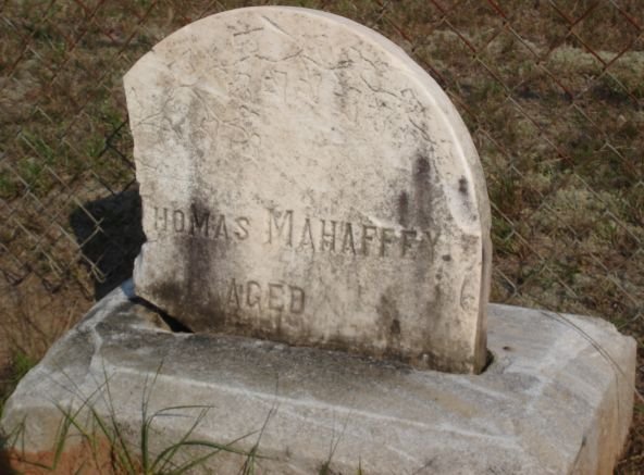
Info: Larry McAdams |
| Massey Family - White | The cemetery was located on the left side of Hwy 18 going up Massey Hill from Gordon. Horses were corralled here and allowed to destroy it. | Info: Larry McAdams |
| Methvin 1 and 2 - White | Both Destroyed | Info: Larry McAdams |
| Thompson Family - White | White Map Destroyed | Info: Harold Thompson |
| Unknown | End of Hartford Road. Destroyed by a logging
company in the 1950's. Upon close inspection, broken slabs and markers
can be found. The broken stones and markers could still be seen at the
end of the road in 1998.
Not found in 2006 |
Info: Larry McAdams |
| Unknown | Smith Road, Southwest. Cemetery was on Smith Rd. at the end of Long Bridge Rd. Kaolin pit is there now. On old maps. | Info: Eileen McAdams, Susan Harrington, Warren Layfield |
| Wynn Family- White | Was near intersection of Little Sandy Creek Rd. & Long Branch Rd. |
01. Celia S. Wynn 8/25/1871 - 10/14/1881 02. U.A. Wynn 3/30/1833 - 8/13/1902 C.S.A. Names are from Wilkinson County Toombstone Records by Joe Maddox, published 1971. If the graves were there they have been moved to Bulloch County. Algeron Cannon writes " The graves are in the Upper Mill Creek Baptist Church Cemetery in Bulloch County. Bulloch County, Georgia Cemeteries, Volume 3, page 119." |